Terra Drone
🇯🇵 JP Bedient global, JP, ID +3
Japanese drone services group offering surveying, inspection and agriculture worldwide.
- Dienstleistung
- Kauf
- Öffentliche Angebotsseite
- 8 Jobs
- 26. Okt. 2026
Luftfahrt und Drohnen
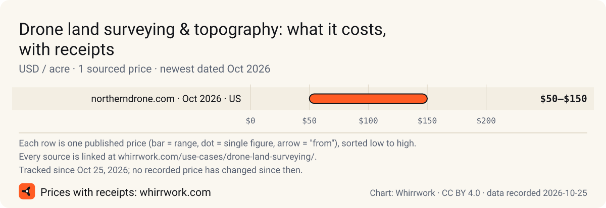
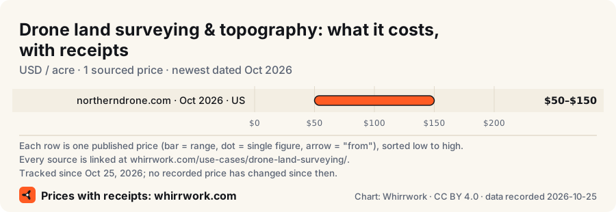
Kurz gesagt Veröffentlichte Preise für „Drohnenlandvermessung und Topografie“: $50–$150 / acre (Preise: 1, Quellen: 1, Vereinigte Staaten; neuester Stand Okt. 2026). Alle Belege stehen weiter unten.
Topografische Erhebungen, Konturen und digitale Geländemodelle mit Photogrammetrie oder LiDAR.
Die Leute verlangen dies als: “Drohne topografische Untersuchung”, “Konturvermessungsdrohne”, “LiDAR-Erhebung”
Zuletzt aktualisiert · Diese Seite zitieren
Faustregeln, kein Verkaufsgespräch. Machen Sie den Leiter-Test →
Veröffentlichte Preisspannen, jede mit Beleg. Keine Angebote: Ihr Preis hängt von Umfang, Ort und Termin ab. älterer Preis = älter als 18 Monate
1 weiterer Beleg in einer anderen Währung oder Einheit: siehe die vollständige Tabelle unten.
Dieses Diagramm einbetten · PNG · SVG
| Was | Spanne | Einheit | Region | Beleg |
|---|---|---|---|---|
| Engineering-grade topographic drone mapping with ground control | $50–$150 | / acre | US | northerndrone.com Stand Okt. 2026 |
| Was | Spanne | Einheit | Region | Beleg |
|---|---|---|---|---|
| Basic drone mapping über Northern Drone | $10–$30 | / acre | — | northerndrone.com Stand Okt. 2026 |
| Engineering-grade topographic mapping with ground control über Northern Drone | $50–$150 | / acre | — | northerndrone.com Stand Okt. 2026 |
| Drone LiDAR über Northern Drone | $50–$300 | / acre | — | northerndrone.com Stand Okt. 2026 |
| Aerial video, photogrammetry and thermal inspection start from MAD 4,500 per project über Creatix Studio | from 4,500 MAD | / project | — | creatixstudio.ma Stand Okt. 2026 |
Datensatz: „Drohnenlandvermessung und Topografie“: Preisbelege (Whirrwork). Veröffentlichte Preise für „Drohnenlandvermessung und Topografie“: 1, jeweils mit Quellenlink und Stichtag. Alte Beobachtungen bleiben erhalten und werden nie überschrieben. JSON · Verlauf als JSON · alle Downloads · CC BY 4.0
Bisher eine Beobachtung. Wir speichern jeden Preis dauerhaft; ein Trend erscheint, wenn eine Quelle erneut geprüft wird und sich der Preis ändert.
| Reihe | Aktuell | Beobachtungen | Erfasst | Trend | Beleg |
|---|---|---|---|---|---|
| Engineering-grade topographic drone mapping with ground control | $50–$150 / acre | 1 | 25. Okt. 2026 ✓ erneut geprüft 25. Okt. 2026 | — | northerndrone.com |
| Basic drone mapping über Northern Drone | $10–$30 / acre | 1 | 25. Okt. 2026 ✓ erneut geprüft 25. Okt. 2026 | — | northerndrone.com |
| Engineering-grade topographic mapping with ground control über Northern Drone | $50–$150 / acre | 1 | 25. Okt. 2026 ✓ erneut geprüft 25. Okt. 2026 | — | northerndrone.com |
| Drone LiDAR über Northern Drone | $50–$300 / acre | 1 | 25. Okt. 2026 ✓ erneut geprüft 25. Okt. 2026 | — | northerndrone.com |
| Aerial video, photogrammetry and thermal inspection start from MAD 4,500 per project über Creatix Studio | from 4,500 MAD / project | 1 | 25. Okt. 2026 ✓ erneut geprüft 25. Okt. 2026 | — | creatixstudio.ma |
Quellen erneut geprüft: 5 von 5 Reihen auf der Live-Quelle bestätigt (letzte Prüfung 25. Okt. 2026). Log: price_rechecks.jsonl
Nur Anhängen: Wir überschreiben nie einen erfassten Preis. JSON: /api/prices/history?use_case=drone-land-surveying
Setzen Sie diese in Ihre Anfrage und Sie erhalten einen echten Preis anstelle von "es kommt darauf an":
Auf Englisch (die Quelle), um falsche Übersetzungen von rechtlichen Details zu vermeiden.
Allgemeine Information, keine Rechtsberatung. Regeln ändern sich: Fragen Sie den Betreiber, welche Genehmigungen er hat, und prüfen Sie sie.
Filtert nach Hauptsitz oder veröffentlichtem Einsatzgebiet.
🇯🇵 JP Bedient global, JP, ID +3
Japanese drone services group offering surveying, inspection and agriculture worldwide.
🇺🇸 US Bedient global
US maker of UAV LiDAR systems and survey services.
🇺🇸 US Bedient US, global
US geospatial services firm including LiDAR and drone surveys.
🇨🇭 CH Bedient global
Swiss VTOL mapping drone maker.
🇦🇺 AU Bedient global
Australian drone survey platform for earthworks and mining.
🇳🇬 NG Bedient NG
Nigerian drone survey company offering multispectral agricultural mapping and 2D/3D models.
🇪🇸 ES Bedient CL
Applus+ drone inspection and topography services in Chile.
🇨🇱 CL Bedient CL
Chilean geospatial firm combining drones, LiDAR and bathymetry for mining and energy.
🇺🇸 US Bedient US
US drone survey and mapping company with published per-acre pricing.
🇪🇬 EG Bedient EG
Egyptian geospatial firm offering drone orthomosaics, terrain models and asset inspection.
🇲🇦 MA Bedient MA
Moroccan drone company for filming, industrial inspection, aerial survey and LiDAR nationwide.
🇸🇦 SA Bedient SA
Saudi drone and geospatial services: aerial/LiDAR survey, industrial visual/thermal/UT inspection, ROV and robotic inspection.
🇸🇦 SA Bedient SA
Dammam-based Saudi provider of drone, ROV, NDT and geospatial inspection services.
🇸🇦 SA Bedient SA
Riyadh drone-as-a-service provider for surveys, mapping, inspections and GACA permit support.
🇨🇴 CO Bedient CO
Colombian drone company for topography, photogrammetry, industrial inspection and crop spraying.
🇨🇴 CO Bedient CO
Colombian drone fumigation, GNSS-RTK measurement and aerial survey services.
🇨🇴 CO Bedient CO, PE
Drone topography, inspection and LiDAR services in Colombia and Peru.
🇿🇦 ZA Bedient ZA
South African drone surveying company: topographic mapping, construction monitoring, stockpile volumes and corridor surveys.
Veröffentlichte Preise für „Drohnenlandvermessung und Topografie“: $50–$150 / acre (Preise: 1, Quellen: 1, Vereinigte Staaten; neuester Stand Okt. 2026). Alle Belege stehen weiter unten.
Gelistete Anbieter für „Drohnenlandvermessung und Topografie“: 18. Länder, in denen laut eigener Website mindestens ein Anbieter arbeitet: 13. Am besten abgedeckt: Saudi-Arabien (4), Kolumbien (3), Chile (2). Anbieter, die nach eigenen Angaben weltweit arbeiten: 5. Wählen Sie auf dieser Seite Ihr Land, um zu sehen, wer dort tätig ist, lokale Anbieter zuerst.
Beginnen Sie mit: Zweck der Umfrage (Topo, Grenze, Design) und ob ein lizenzierter Vermesser sie unterschreiben muss; erforderliches Koordinatensystem und vertikales Datum; Ort (Adresse oder Koordinaten). Die vollständige Checkliste hat insgesamt 9 Punkte. Eine Anfrage, die sie abdeckt, bekommt einen echten Preis statt „kommt darauf an“.
Nicht immer. Wenn eine fähige Person mit einer Leiter es an einem Nachmittag schafft, beauftragen Sie die Person (der Leiter-Test, auf Englisch). Der Haken bei diesem Job: Fragen Sie nach einem Nachweis der Pilotenzertifizierung und Haftpflichtversicherung (oft $ 1M +).
Kurz gefasst (englisches Original): Survey-grade deliverables usually must be certified by a licensed land surveyor; drone flights follow Part 107/EASA/local rules. Mehr zu den Vorschriften (eine Zusammenfassung, keine Rechtsberatung)
Whirrwork. "Drohnenlandvermessung und Topografie: Kosten, Ablauf und Anbieter." Zuletzt aktualisiert 2026-10-26. https://whirrwork.com/de/use-cases/drone-land-surveying/. CC BY 4.0.
@misc{whirrwork_drone_land_surveying_de,
  title = {Drohnenlandvermessung und Topografie: Kosten, Ablauf und Anbieter},
  author = {{Whirrwork}},
  year = {2026},
  url = {https://whirrwork.com/de/use-cases/drone-land-surveying/},
  language = {de},
  note = {Last updated 2026-10-26. CC BY 4.0. Prices link to their original sources.}
}
Sie zitieren einen Preis? Nennen Sie auch die Originalquelle (in der Tabelle verlinkt). Wir sind das Verzeichnis, nicht der Ursprung. Geben Sie das Datum an, an dem Sie diese Seite gelesen haben.
Jeder Beleg hinter der Spanne, ein Balken pro veröffentlichtem Preis, die Quellenangabe ist ins Bild eingezeichnet. Nutzen Sie den iframe für anklickbare Quellen oder den Bildcode für Newsletter, Folien und Markdown. Das Diagramm ist auf Englisch.
Ein Formular. Wir finden Anbieter, die Ihr Land abdecken, und leiten die Anfrage weiter. Kostenlos.
Kostenlose Angebote anfragen